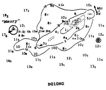
Which statement concerning the chartlet seen in illustration D010NG below is TRUE? (Soundings and heights are in meters)
Official USCG Answer & Rule Citation
Correct Answer: Option B — There is a dangerous eddy southeast of Beito Island.
Chart symbols and notes provide critical hydrographic data. The notation of a dangerous eddy southeast of Beito Island warns mariners of localized currents that can affect vessel handling and steering. Accurate interpretation of these chart features is essential for safe passage planning and avoiding navigational hazards.
100% Free & Open Access — No daily limits, paywalls, or gated answers on BrightMariner.